Iceland 2018: Preparations
Before we talk about or Iceland hike in 2018 , we would like to present the things we considered while preparing our journey.
A long time ago, we decided to travel to Iceland. Finally, on the 18th of July in 2018, we went into the plane, but a lot of things had to happen until then.
This will be some kind of FAQ with some information, hints and experiences to prepare yourself.
Key information
- Iceland 18/09/2018 to 10/08/2018 (24 days)
- Region around Þórsmörk - Eldgjá - Langisjór -Landmannalaugar
- Without campsite, hotel or supermarket during the time
- Persons: both of us (Kristina and Hauke)
- Experience: medium to little
- Physical condition: Moderate to untrained
Planning key details
First we clarified the most basic information:
- When?
- How long?
- What to we want to see?
We could easily answer these questions, because holiday and budget were two important factors. We decided to use our whole holidays to be there from the 18th of July until the 10th of August (that are 24 days). Originally we wanted to start at the 20th/21st but the flight on the 18th was cheaper.
We roughly decided what we want to see. Definitely a hot spring, black desert and many green mountains.
After that, we clarified some details:
- In what region?
- How to get there?
- What route to choose?
We had to do some research to answer these questions, especially as we didn’t know Iceland.
Find the right region
We just looked on Google Maps and found places we like. Some places were fixed (e.g. Langisjór or Mælifell), because we saw them earlier on the internet and absolutely wanted to see them.
We learned that there are areas, that are nearly not mapped at all. For example there aren’t any information for the route from Langisjór to Landmannalaugar: no information about the conditions, no photos and only a few trip reports. Later we thought about alternative routes, to get rid of this uncertainty.
The final route started in Þórsmörk and went to Landmannalaugar. More about the route in the separate travel reports.
Arrival and departure
One thing was clear: We’ll go there by plain. But then?
The first night will be in Reykjavík on the campsite, but we didn’t know how to get there. We searched a lot and always thought about alternatives. In the end we planned the following:
We wanted to take the FlyBus from Keflavík to Reykjavík (BSÍ), then go shopping and in the evening go to the campsite (you can definitely walk the distance and you see something from Reykjavík).
For the trip to the highlands (and back) we booked tickets at Reykjavík Excursions, it was the most comfortable choice. Depending on the route there might be a better provider, but for us it was fine.
The FlyBus should also take us back to the airport and we planned to have some connection time at the BSÍ.
There will probably be a separate article about the transport.
Source of information
We primarily got our information from friends and forums in the internet. There are also books and other sources for information and advices, but we haven’t bought any books or such.
We read a lot of articles like this. They were more or less helpful but as soon as we found photos of difficult/critical points (e.g. a ford), they helped us during the planing of our route.
On YouTube there are a lot of videos of iceland, which is very helpful because you can see how deep a ford is or how the landscape actually looks like. There are also e.g. timelapse videos, which give a good impression on the landscape, roads, weather and ground conditions. They are also funny because it feels like sitting in a race car with speaking mice :D
Furthermore there’s also reddit where several subreddits (some kind of sub-categories) exist about ultra light, visiting iceland und hiking in general. We also used classical forums like the german outdoorseiten.net. Those good old forums are the most helpful source of information and there are also a lot of good english forums.
Don’t get confused by feedback
Critique is always a problematic thing: There’s good and bad criticism.
Some people are giving you good critique, showing alternatives or talk abut their experiences. Other people only say that your plan is absolutely stupid but don’t offer a better solution.
Don’t be confused or demotivated by such bad criticism, just collect other peoples thoughts and decide on your own what you change on your plan. Don’t rely blindly on other people!
Our experience with criticism in the internet
It was not our intention to do an easy-peasy walk in Iceland. Many people see a hike (or maybe also trekking) as a kind of easy relaxing walk and discouraged us from doing such a journey as we planed it (you’ll see the reason for that in the later reports).
When looking back, many people were not really right. There was a lot of good and helpful feedback but we didn’t followed a lot of advises and made compromises.
For example: Everybody discouraged us from taking all the food for the 24 days with us, which results in a 30kg backpack. But we did it, it wasn’t easy but it worked.
Create a route
Once you have some travel destinations, you can start to create your route. Here you should go into detail but also leave space for alternatives. And in general: It comes different than you now may think.
First we looked at interesting parts like cliffs or rivers, that cannot be crossed. Generally all kind of obstacles.
We marked everything we saw (e.g. a ford) and searched for alternatives, e.g. a bridge down the river.
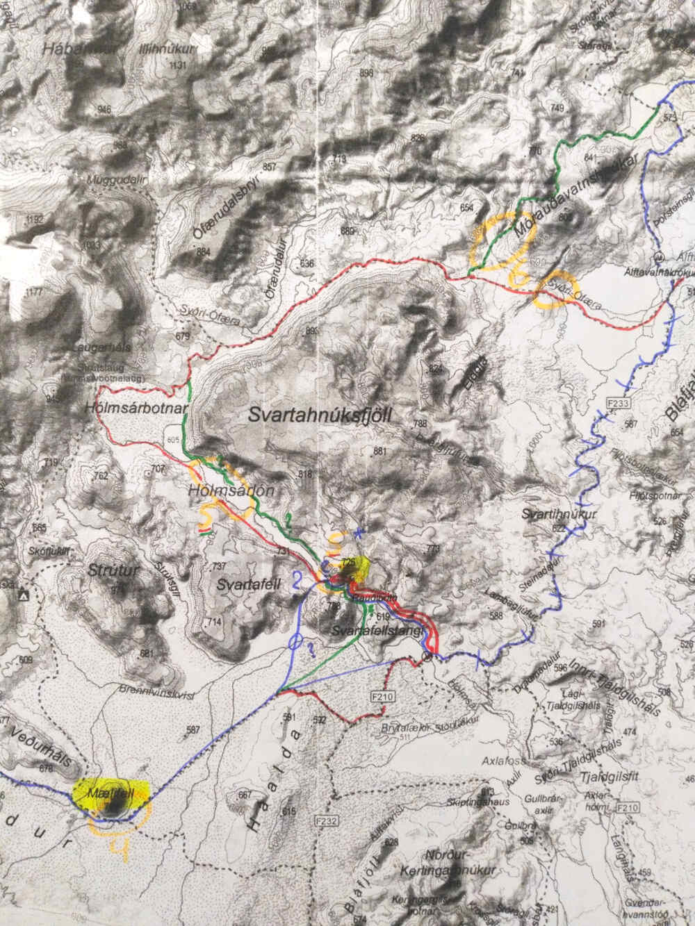
Maps
We bought a hiking map, scanned it and digitally marked our route on it. We then were able to search for alternatives and change the route without making the actual hiking map unreadable.
Free (or just even free accessible) map material with a usable amount of details is really rare. OpenStreetMap (OSM) is a really great project and sometimes contains more details then proprietary maps. No wonder that companies like Garmin create their maps based on OSM. Nonetheless there are several sparsely mapped regions in Iceland.
If you want to have aerial imagery maps (like Google-Earth), use map.is. This service contains high resolution images of whole Iceland. Good alternatives are the maps from Google, Bing and ESRI. However, aerial imagery of remote areas is often outdated, full of clouds or snow and often the image quality is simply bad.
We sent our final map with our planed route to friends and relatives so that they were able to know where we approximately were.
Equipment
A really interesting topic.
We read a lot of experience reports on the internet on what to pack into the backpack, asked people in forums and talked with people in our favorite outdoor store. In the end we used a lot common sense, like we did on our route.
When you have friends, who did a similar journey, definitely ask them about their experiences. Directly asking people (e.g. in a forum with a private message) can also help a lot.
Minimize weight
The topic about weight is even more interesting. We planned to take 25 to 30kg with us. When you can save some grams on several places, you are very happy.
For example: We took only one cooker with us and one set of dishes (two plates, one big cup, one small cup). Don’t save weight on your sleeping bag, we replaced a 1,8kg sleeping bag with a 0,7kg one but I don’t recommend it to anybody! When it becomes cold (which is very likely), it’s not only uncomfortable but can become unhealthy very quickly!
Food
For us an even more interesting topic.
A lot of people say that you burn twice as much calories on a trekking tour as in your normal daily life. Generally this is true! Each of us had to eat food worth of 4000 to 5000kcal per day.
Lets calculate…
If we say that the average calories are 450kcal/100g (roughly the average of normal food and nuts), each person has to carry one kilogram of food per day. For 24 days this makes 24kg of food. Probably this is possible to carry with you but that was too much for us. You also need a special back pack and some other equipment to carry all of your stuff.
Each of us had 13kg of food in Iceland. Clearly we didn’t reached our 4000-5000kcal goal. Get to know you body, it’s possible that you loose some kilos during the hike.

Note: More hunger near the end
An important note at this point: Approximately after half of the tour, we were more hungry. It’s better to calculate with 1,5 meals at the end to not be hungry after eating.
Eat one of your meals before you start your journey and see how hungry you are afterwards.
Conclusion
Planing is the most important part. Don’t rely blindly on other people and always create alternatives! The internet is great but doesn’t always tell the truth and not everything is relevant.
Decide on your own thoughts and learn from the mistakes other people have made! Common sense is here the key to success.
If you are currently planning your own tour: Have fun while planning and enjoy your journey even more! :)